 |
Did Excavators Find the Seleucid Citadel in the Givati Parking Lot?
|
Because the Haram esh-Sharif has been falsely identified as the temple mount, rather than the Roman camp Antonia, there have been many erroneous proposals for the location of the Israelite and Seleucid citadels. The literary evidence, therefore, places the Seleucid citadel in the lower city of the Greek period, which would have been the lower half of the southeastern hill, the former City of David. |
by Marilyn Sams
Since 2007, parts of the Givati parking lot excavation on the southeastern hill of Jerusalem, conducted by Doron Ben-Ami and Yana Tchekhanovets, have been characterized as the remains of Queen Adiabene’s palace and also the Seleucid Acra. Both of these faulty identifications are based on a misunderstanding of and/or lack of attention to literary descriptions which place both of these constructions in the lower city, formerly the City of David, called “Acra,” starting in the Greek period.
“Acra” (meaning “citadel” in Greek) stands for both the citadel itself and the area it occupied -- the lower city. Josephus and First Maccabees place them both south of the temple, which was in the middle of the southeastern hill, and also verify that Simon Maccabee not only destroyed the citadel, but also the hill on which it stood. Therefore, there were no remains remaining. This paper will set forth the literary evidence evidencing the citadel’s actual location, which was also near the location of Queen Adiabene’s palace.
Citadels Preceding the Seleucid Citadel
Because the Haram esh-Sharif has been falsely identified as the temple mount, rather than the Roman camp Antonia, claimed by eyewitness Eleazar ben Ya’ir to be the only monument remaining after the 70 A.D. destruction (War VII, 8, 376), there have been eight erroneous proposals for the location of the Israelite and Seleucid citadels. [1]However, they were all in the same location, starting with the Jebusite citadel (called “Millo” in Samuel, Kings, and Chronicles), where David resided before building his palace across from it in the newly renamed City of David (Antiquities VII, 3, 65).
The northern boundary of this city can be assumed to be the Middle Bronze Age II and Iron Age I walls found in Kathleen Kenyon’s Area H at the bottleneck of the southeastern hill. Hence, the City of David covered roughly the lower half of the southeastern hill. In 3 Kings 2:35 (Septuagint version), we discover that Solomon expanded this city by breaching its northern wall and adding the “wall of Jerusalem,” a fortification which would then protect the northern half of the southeastern hill and the daughter of Pharaoh in the palace he had newly built for her, outside the City of David. [2]
The crescent shape of the City of David/Jerusalem (the shape of the southeastern hill) is witnessed by accounts in Josephus, Aristeas, Tacitus, and the Venerable Bede, confining the city to the southeastern hill, with no northerly extension described. [3]It is notable from the Septuagint scripture that Solomon did not breach the City of David’s wall until he had already built the temple and his own palace and rebuilt the citadel. [4]
Since the temple was built on Mount Zion at the border between Benjamin and Judah, above En Shemesh (Spring of the Sun -- the Gihon Spring), Solomon’s citadel replaced the former Jebusite citadel and acted as a landmark (along with the temple) demarcating the Benjamin/Judah borderline. [5] Hezekiah repaired this citadel (2 Chronicles 32:5), Nehemiah mentioned it in the Persian period (Nehemiah 7:2), and Josephus described it during the conquest of Jerusalem by Antiochus the Great (Antiquities XII, 3, 133).Antiochus Epiphanes IV, the son of Antiochus the Great, replaced the citadel of these descriptions with a new one in the same place.
The “Lower City,” “Acra,” and the “City of David”
As noted by archaeological excavations or the lack thereof, the “city” of the Persian and Greek periods reverted to the southeastern hill only. [6]Therefore, the “lower city” of those periods was the area south of the temple, which edifice Hecateus of Abdera (c. 4th century B.C.) described as occupying the “middle” of the city (Contra Apion I, 22, 198), a location shared by the Gihon Spring (Shiloah), as noted in Hagigah 76a of the Jerusalem Talmud. The Letter of Aristeas also implies the temple’s bifurcation of the city by describing “upper towers” and “lower towers.”
In Antiquities XII, 5, 252, Josephus recounts Antiochus Epiphanes’ 168 B.C. conquest of Jerusalem, after having overthrown the walls, and his building a citadel in “the lower part of the city:”
"He also burned down the finest buildings; and when he had overthrown the city walls, he built a citadel [Acra] in the lower part of the city, for the place was high, and overlooked the temple; on which account he fortified it with high walls and towers, and put into it a garrison of Macedonians. (italics and bracketed Greek terms or other information mine, as in all further quotations)."
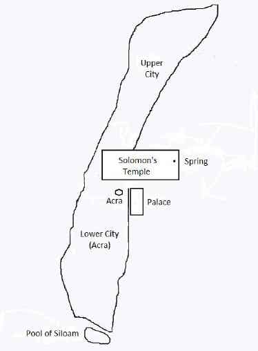
Fig. 1.The Upper and Lower Cities on the Southeastern Hill
|
|
Fig. 1.The City of David/Jerusalem occupied only the southeastern hill in the Greek period, as witnessed by archaeological excavations in Jerusalem. The “upper” and “lower” cities refer to the areas north and south of the temple. The Acra stood south of the temple in the lower city.
The towers and immense stones of the citadel are described by Aristeas and the height of the “place” of the citadel recalls the 3 Kings 2:35 passage which says Solomon built his citadel “above” the temple, implying the Seleucid citadel replaced the former Solomonic citadel in the same place. The descriptions of the citadels’ location as being “above” and “high” and “overlooking the temple” are factors which have been minimized, ignored, or dismissed in the false locations posited for all the citadels.
The literary evidence is clear that the citadels were in a place higher than the temple in the lower city -- that part of the city, in both the Israelite era and the Greek era, being limited to the lower half of the southeastern hill.
The reason for the height of the citadel being greater than the temple appears to derive from the difference in height between two natural hills, which were likely augmented by occupational tels (because of the spring), dating from 3,000 B.C., with Mount Zion, the hill on which the temple was built, being the lower of the two.
Antiochus Epiphane’s destruction of Jerusalem is also set forth in Maccabees 1:31-36, but in these verses, Acra, or the “lower part of the city” is referred to as the City of David:
"And when he [Antiochus] had taken the spoils of the city, he set it on fire, and pulled down the houses and walls thereof on every side…Then builded they the city of David with a great and strong wall, and with mighty towers, and made it a strong hold for them,…For it was a place to lie in wait against the sanctuary, and an evil adversary to Israel."
Hence, the citadel built by Antiochus and occupied by his soldiers became a snare to the Judahites, rather than a protection to the temple, as had been its previous role.
The tide turned, however, when Judas Maccabeus made an assault on the garrison of Macedonians in the “upper city…[and] drove the soldiers into the lower, which part of the city was called the Citadel [Acra]” (War I, 1, 39). Since the city of this period occupied only the southeastern hill, the “upper city” was north of the temple, and the “lower city” was south of the temple and called Acra, because the citadel stood there (just as the area around the citadel called Millo had also been called Millo).
It appears from later descriptions that the Macedonian soldiers driven into the lower city were forced to reside in Antiochus Epiphanes’ citadel. Hence, the War passage explains why the Givati parking lot (located in the “upper” area of the southeastern hill) yielded lead sling shots, bronze arrowheads, and catapult stones stamped with Antiochus IV’s symbol, and coins from his era (Fessenden, 2015).The Macedonian soldiers had been there, in the “upper city,” before Judas drove them into the “lower city.” But it was in the lower city, not the upper, where the Seleucid citadel stood.
The Macedonian soldiers trapped in the citadel after Judas’s retaking of the city continued to create problems under Jonathan and Simon. In Antiquities XIII, 5, 181-182, an attempted solution is set forth:
"When Simon and Jonathan had finished these affairs, they returned to Jerusalem, where Jonathan gathered all the people together, and took counsel to restore the walls of Jerusalem, and to rebuild the wall that encompassed the temple, which had been thrown down, and to make the places adjoining stronger by very high towers; and besides that, to build another wall in the midst of the city, in order to exclude the marketplace from the garrison, which was in the citadel [acra] and by that means to hinder them from any plenty of provisions…."
This proved to be a successful step, as witnessed in 1 Maccabees 13:49-50, 52:
"They also of the tower [acra] in Jerusalem were kept so strait, that they could neither come forth, nor go into the country, nor buy, nor sell: wherefore, they were in great distress for want of victuals, and a great number of them perished through famine. Then cried they to Simon, beseeching him to be at one with them: which thing he granted them; and when he had put them out from thence, he cleansed the tower [acra] from pollutions….Moreover the hill of the temple that was by the tower [acra] he made stronger than it was, and there he dwelt himself with his company.
The passage shows the hill of the temple and the hill of the citadel were adjacent, and, as previously noted, both in the lower city -- the City of David. The point is reinforced in 1 Maccabees 14:36-37, where the City of David is noted as the location of the citadel:
"For in his [Simon’s] time things prospered in his hands, so that the heathen were taken out of their country, and they also that were in the city of David in Jerusalem, who had made themselves a tower [acra], out of which they issued, and polluted all about the sanctuary, and did much hurt in the holy place: But he placed Jews therein and fortified it for the safety of the country and the city, and raised up the walls of Jerusalem."
Moreover, in Antiquities XII, 9, 362, Josephus says the “citadel adjoined to and overlooked the temple." The proximity of the citadel to the temple is also witnessed in the Letter of Aristeas, where, from the height of the citadel, he describes the sanctuary’s door fastenings.
The demise of the Seleucid citadel is chronicled in Antiquities XIII, 6, 215-217:
"He also took the citadel [acra] of Jerusalem by siege, and cast it down to the ground, that it might not be any more a place of refuge to their enemies when they took it, to do them mischief, as it had been until now. And when he had done this, he thought it their best way, and most for their advantage, to level the very mountain itself upon which the citadel [acra] happened to stand, that so the temple might be higher than it.
"And indeed, when he had called the multitude to an assembly, he persuaded them to have it so demolished and this by putting them in mind what miseries they had suffered by its garrison and the Jewish deserters, and what miseries they might hereafter suffer in case any foreigner should obtain the kingdom, and put a garrison into that citadel…so they set themselves to the work, and leveled the mountain…after which the temple was the highest of all the buildings, now the citadel, as well as the mountain whereon it stood, were demolished."
The citadel and the mountain on which it had stood had been higher than the temple, a situation which does not comport with the location of the Givati parking lot with reference to the alleged temple mount, which is higher, to its north.
Another passage describing the demolition of the hill on which the citadel stood is mentioned in War V, 4, 139, where Josephus states that the Hasmoneans “took off part of the height of Acra, and reduced it to be of less elevation than it was before, that the temple might be superior to it." If Acra were the whole southeastern hill and the Haram the area of the temple, it would have been unnecessary to take off any height from the citadel or its hill for the temple to be higher.
The literary evidence, therefore, places the Seleucid citadel in the lower city of the Greek period, which would have been the lower half of the southeastern hill, the former City of David. It also witnesses that Simon demolished the citadel and the hill it stood on, radically altering the topography of the southeastern hill. No structure proposed for the Seleucid citadel can be genuine, because Simon obliterated everything.
The Palace of Queen Adiabene
Previous to “finding” the Seleucid citadel in the Givati parking lot excavation, excavators identified the basement floor of a large residential building, dated to the Second Temple era, as part of the palace of Queen Helena of Adiabene, based on some sherds, coins, and a fragmentary inscription from the area where she originated (“Givati Parking Lot,” 2012).
Fig. 2.The Givati Parking Lot Excavation
 |
Fig. 2.The Givati parking lot excavation is located north of the City of David, whose northern boundary was at the bottleneck of the southeastern hill, while the Acra, the location of both the Seleucid citadel and the palace of Queen Adiabene, was located in the City of David to the south.
In the Roman period, the definition of “lower city” can refer to the whole southeastern hill or the southern portion of the southeastern hill, it having been leveled by Simon the Hasmonean. In addition to destroying the citadel and leveling the hill, Simon also presumably destroyed the royal palace, because he built a new palace on the western hill. Or, the old palace could have been subsumed in Herod’s expansion of the temple to the south. The space remaining after the temple’s expansion included the Ophla plaza south of the temple, lanes and houses, and the palaces of Monobazus, Izates, and Queen Helena. In War, V, 6, 252-253, the lower city is described as Acra, just as it had been in the Hasmonean era:
"Simon [bar Giora] held the upper city, and the great wall as far as Cedron, and as much of the old wall as bent from Siloam to the east, and which went down to the palace of Monobazus, who was king of the Adiabeni, beyond the Euphrates; he also held that fountain, and the Acra, which was none other than the lower city; he also held all that reached to the palace of Queen Helena, the mother of Monobazus."
The passage locates Simon’s possessions in the lower area of the southeastern hill, where the Kidron Valley met the great wall in the valley, and the old wall on the ridge bent from the fountain of Siloam to the east. It therefore appears that the palace of Monobazus stood on the eastern slope of the southeastern hill and Queen Helena’s was on the ridge, in the middle of Acra, as mentioned in the following passage:
"But on the next day they set fire to the repository of the archives, to Acra, to the council house, and to the place called Ophlas; at which time the fire proceeded as far as the palace of Queen Helena, which was in the middle of Acra (War, VI, 6, 354-355).
It is evident from the context of these descriptions that Josephus was referring to the southern area of the southeastern hill as the lower city or Acra, indicating that Queen Helena’s palace was not in the north in the Givati parking lot, but in the area south of Herod’s temple (in the middle of the southeastern hill), the former City of David.
End Notes:[1]Differing locations for the citadels have been given as (1) the area of the later alleged traditional Baris, north of the Dome of the Rock, (2) south of the Dome of the Rock to the west, (3) south of the Dome of the Rock at Wilson’s Cistern #11, (4) somewhere on the western hill, (5) partly in and partly out of the southern wall of the Haram, (6) at the top of the Stepped-Stone Structure, (7) the Spring Tower of Reich and Shukron’s Gihon Spring excavations, and (8) the Givati parking lot excavation.
[2] Eilat Mazar characterizes the Large Stone Structure in her southeastern hill excavation as David’s palace, which was actually south of the Gihon Spring. It may, however, be the daughter of Pharaoh's palace, as it is in an area likely protected by the “wall of Jerusalem,” and Mazar uncovered 3,000 fish bones from the Bardawil Lagoon and others possibly from the Nile within the excavation area (See Biblical Archaeology Review, “The Interrupted Search for King David’s Palace” [Shanks, 2016 Jul/Aug]).
[3] The crescent shape of the city is described by (1) The Letter of Aristeas mentioning the city had “its towers arranged in the manner of a theater,” (2) Josephus declaring it “as the shape of a moon when she is horned” (War V, 4, 137), (3) Tacitus noting its walls “bending inwards,” (Historiae 5, 11), (4) The Venerable Bede writing that the so-called Mount Sion rose above the city “like before an arc” (De Locis Sanctis), and (5) Josephus witnessing that “the city [on the western hill] lay near to the temple in the manner of a theater, and was encompassed with a deep valley along the entire south quarter [the confluence of the lower Tyropoeon, Hinnom, and Kidron valleys]….” (Antiquities XV, 11, 410).<>
[4]
3 Kings 2:35 (Septuagint version): “…And the wisdom of Solomon abounded
exceedingly…and he took the daughter of Pharaoh, and brought her into
the city of David, until he had finished building his own house, and the
house of the LORD first, and the wall of Jerusalem round about. In
seven years he made and finished them…and Solomon made the sea, and the
bases, and the great lavers, and the pillars, and the fountain of the
court, and the brazen sea -- and he built the citadel as a
defense
above it, he made a breach in the wall of the city of David: thus
the daughter of Pharao went up out of the city of David to her house
which he built for
her….
[5]See Joshua 18:16-17; Psalm 78:54; Psalm 74:2; Zevachim 54b; Zevachim
118b; Megilah 26a
[6]Cahill and Tarler (1994) have said “The well-stratified deposits of the
Persian period discovered in the City of David stand in sharp contrast
to the lack of comparable remains from other excavated areas of
Jerusalem. This suggests the City of David was the city’s main center
of occupation during this period” (p. 41).The problem with this
statement, however, is in identifying the entire southeastern hill as
the City of David. Greek and pre-Simon Maccabeus finds are also lacking
in areas outside the southeastern hill.
TOI, Staff. (2015, Nov. 3). A 2,000 year-old Greek fortress has been
unearthed in Jerusalem. Retrieved from The Times of Israel website:
https://www.timesofisrael.com/maccabean-era-fortress-unearthed-in-jerusalem-after-century-long-search/
Givati Parking Lot.
(2012). Retrieved April 15, 2013, from City of David website:
http://www.cityofdavid.org.il/en/archeology/excavations/givati-parking-lot Hope of
Israel Ministries -- Preaching YEHOVAH's Truth Without Fear or
Favor! Hope of
Israel Ministries
P.O. Box 853
Azusa, CA 91702, U.S.A.
www.hope-of-israel.org

Scan with your
Smartphone for
more information